Zorrozaurre masterplan for Bilbao by Zaha Hadid Architects
Zaha Hadid Architects have formally launched the masterplan for Zorrozaurre, a 60 hectare peninsula in the Nervión river in the former port area of Bilbao, Spain.
The architects have been working on the masterplan, which will turn the peninsula into an island with homes and offices, for several years.
The info below, provided by the architects, is from 2004:
--
ZORROZAURRE
Data Sheet Text
27/10/04
LFB
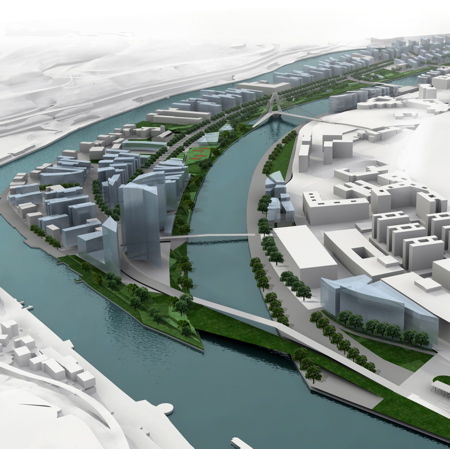
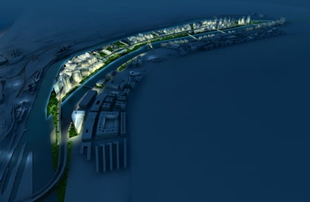
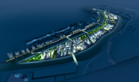
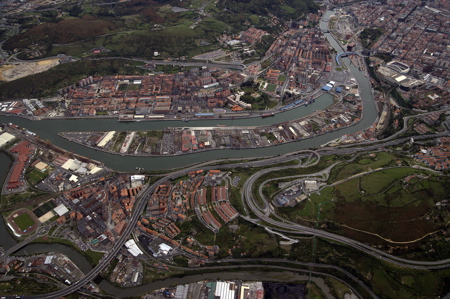
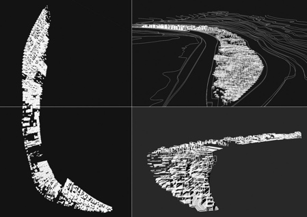
Zaha Hadid has completed the conceptual masterplan for Zorrozaurre in Bilbao, a 60 hectare area cradled in a long curve of the Nervion River just across from the city’s centre. This former port and industrial area will become home to nearly 15,000 new residents and will provide workshops, labs, studios, and offices for nearly 6,000 working people. Zorrozaurre has been nearly separated from its neighbouring communities by a canal opened to enlarge the port during its heyday, and this canal is destined to be extended for flood-control purposes in future years. This will make Zorrozaurre an island occupying a strategically key position in the future expansion of the city and integration of the region. Zaha Hadid Architects have responded to this challenge by defining a dramatic urban fabric and bold approach to infrastructure and the waterfront that will highlight the great significance of its natural and strategic position.
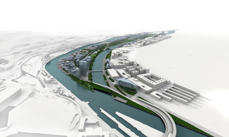
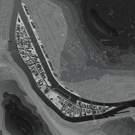
The plan permits the dramatic character of Zorrozaurre’s surrounding topography and the broad curve of the Nervion to subtly influence Bilbao’s well-defined urban grid. The resulting building alignment generates a finely textured ground sweeping the length of the site, contracting to conform to the small scale of existing fabric and expanding in response to more open spaces. In this way the plan accommodates both historic buildings and major new investment, while linking both to a generous public waterfront. Zorrozaurre’s future skyline presents a jagged profile with fine gaps, reminiscent of densely built waterfronts around the world. Zorrozaurre will be well integrated with its neighbours on both banks of the Nervion by an exciting sequence of bridges. These will allow the river itself to become a meaningful part of the daily life of local communities along the banks. Equally important to the transport system, Bilbao’s existing tram system will be extended the length of Zorrozaurre and beyond, establishing a central spine of activity running through the island and linking the region’s downstream communities to the city’s centre. The plan aims to set the trend for a regionally integrated city, defining new patterns of living and working within the context of a distinctively strong local identity.
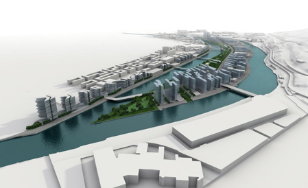
At the heart of the plan for Zorrozaurre, an elegant system of building blocks enables the achievement of both skyline and collective ground. These building blocks are like a set of “tiles,” each over 1000 m2, and they allow the ground formation to respond to the curving spine of the river, the street grid, and the shifting orientation of buildings from upstream to downstream. In this way, the tiles give the plan an overall unity while allowing the differentiation of districts and clusters. The platform level of the tiles establishes the critical level of defence against floods while also creating space for underground parking. By linking this critical level to the development of building clusters, the waterside promenade can dip closer to the normal level of the river, allowing the people of Bilbao a closer engagement with the water’s edge. Meanwhile, above the platforms, the buildings are turned perpendicular to the long axes of the river, opening the building fabric so that pathways and views may be enjoyed by all. The rich pattern of public and private spaces we see in the plan can be achieved through the subtle differentiation of levels, promoting an easy balance between the needs of privacy and the pleasures of community life. The overall structure organizing the tiles permits a densely built environment to accompany the fabric’s strong feel of porosity, with future residents and workers all enjoying a rich tapestry of outdoor places. Waterside promenades, parks, the tree-lined central avenue, small squares, and public gardens—all link together to create a textured setting for urban social life.
The plan promotes the development of three loosely-defined districts that effectively integrate with their neighbours across the water, establishing together with them larger and more complex urban areas that will be able to meet the challenges of regional economic change in evidence across Europe. Upstream, Zorrozaurre lends itself to a natural urban intensification. Just across the river from the Bilbao’s 19th century core and conveniently located among centres of learning, medicine, business, and engineering make this area an ideal knowledge-economy district. The built fabric here will be sharper and tighter than in the two downstream districts, integrating the existing historic waterfront into a compelling fabric of offices and residential buildings. Courtyards and public passages create a porous and intricate environment linking old and new. The middle district mirrors the openness of Sarriko Park across the canal, drawing upon the strength of the landscape to establish a strong coherence among historic buildings of very different character. There is an enticingly grand scale to be preserved in the more interesting industrial buildings, with these potentially providing workshops, studios, and classrooms for the further development of local arts-based industries. Meanwhile, the small-scale existing neighbourhood that gathers close around the local church retains its intimacy amongst the trees of an adjoining park where a small amphitheatre provides a venue for outdoor performances. The district offers itself as a centre for arts, sports, and environmental science, connecting via a “green bridge” to the university and Sarriko Park. The openness of the site creates an opportunity for the development of sports facilities with a wider regional appeal, while the waterside park establishes an important local amenity for surrounding communities. Downstream, Zorrozaurre will establish a concentrated urban node within the long-term regional development of the Ria, with a set of new bridges creating an essential urban link between across the banks of the Nervion. The district is defined by its close integration with the water, with local docks to moor small private boats, ponds, boardwalks, and waterside bars to encourage a relaxed leisure culture along the canal. Together, the districts, the ground formation generated by the tiles, and the skyline present an overall picture of a differentiated unity.
Above: urban form
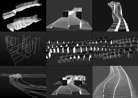
Above and below: early studies
 ZORROZAURRE MASTER PLAN, BILBAO [BILBAO, SPAIN]
2003 / 04 - Urban Development
PROGRAM: Refurbishment and construction of housing, new industries, tertiary uses, urban and recreational spaces and new connections linking the peninsula, city and surrounding areas.
CLIENT: Management Committee for the urban development of the peninsula of Zorrozaurre, Bilbao [Spain]
ARCHITECT: Design Zaha Hadid with Patrik Schumacher
Competition and Phase A
Project Architect / Project Manager Gunther Koppelhuber / Kim Thornton
Phases B/C/D
Project Architect / Project Manager Manuela Gatto
Local Firm Arkitektura Eta Hirigintza Bulegoa S.A. [Spain]
CONSULTANTS
Engineer Ove Arup & Partners [UK]
Traffic Engineer Leber Planificación e Ingenieria S.A. [Spain]
Landscape Architect Gross Max [UK]
Urban Strategy Larry Barth [UK]
SIZE/AREA: 60 hectare