Herzog & de Meuron unveil first buildings of Lyon masterplan
News: Swiss architects Herzog & de Meuron have revealed designs for the first eight buildings of their 35-hectare masterplan for La Confluence, an extension of the city centre in Lyon, France (+ slideshow).
Herzog & de Meuron are overseeing phase two of the La Confluence regeneration plan, an initiative started by the Greater Lyon authority in 1998 to revitalise a stretch of land at the junction of the Rhône and Saône rivers that before now accommodated little besides industrial warehouses, a wholesale market and a prison.
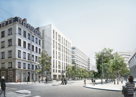
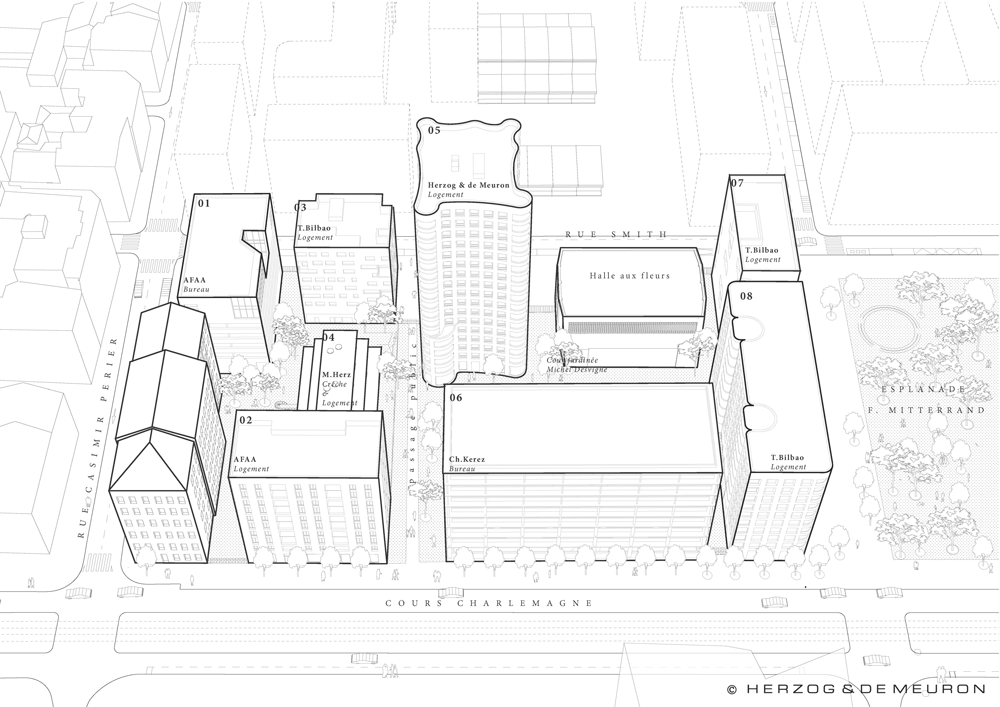
Lot A3 will be the first completed block of the mixed-use masterplan and comprises a total of eight new buildings, including a 17-storey tower by Herzog & de Meuron and smaller buildings by architects including Christian Kerez, Tatiana Bilbao and Manuel Herz.
Located within the area dubbed the Market Quarter, the buildings are due to be completed by 2017 and will include a mixture of residences, offices, shops and other public amenities.
"[It] is a pilot project that aims to invent a way of living that is characteristic of the new quartier du marché," said the architects. "With its remarkable location, the ambition of Ilot A3 is to link different parts of the existing and future city."
French landscape architect Michel Desvigne is working alongside Herzog & de Meuron on the project.
Scroll down for an overview of the masterplan from Herzog & de Meuron:
Lyon: Nature and the city
The Confluence of the rivers Rhône and Saône are Lyon's very "raison d'être". As early as the first century BC the Romans built fortifications at the precise point where the Saône crosses the chain of hills to the west of the city before flowing into the Rhône. Lyon then spread to the east as it developed. Initially on the peninsula bracketed by the two rivers and, once this area was completely occupied, beyond the Rhône and out on to the eastern plain.
Not only did the development of the city follow the logic of the natural environment, but its building types were a reaction to the local topography. The constructions on the hillsides are distinctly different from those at the waterside, and those bordering on the Rhône are different again from those on the Saône. Lyon's identity is thus founded in this direct relationship between architecture and nature. It was not until the 20th century, when the city was beginning to spread to the plains – with no natural constraints – that generic urban architecture, interchangeable with that of any other city, began to appear.
Urban development of the southern tip of the peninsula therefore offers a major opportunity to write a significant chapter in Lyon's history, in which urban development is inseparable from the natural environment.
The Confluence: From Marshland to city centre
Apart from a few port infrastructures, the Confluence remained undisturbed for many years, because the river courses were unpredictable and the land unworkable. It was only after the banks were consolidated that the peninsula became stable ground and land with potential for the city, a space for utopias.
It all comes down to the same question, should the island tip be a space for nature or should it be built up? Should it embellish the city, like the naturalist park projects of the 19th century? Should it be glorified by the addition of a monument, as Tony Garnier suggested in his Cineplex proposal in 1924? Should it be gradually covered over by the spreading city, devoured like the north of the peninsula?
None of these radical visions ever came to pass. Instead, the district had the time to develop almost unnoticed. The marché de gros, the gendarmerie, the SNCF, a circus, a prison and prostitution, all based activities here – activities generally relegated to the edges of cities. In recent years, two town planning competitions have been organised and a new bit of the city, La Confluence Phase 1, is now on the point of being built. This includes a hub combining leisure facilities and retail outlets interspersed with generously proportioned green spaces leading to a wide embankment running along the Saône.
The theme of the present project is based on the offering of a new vision on the La Confluence Phase 2 site at the location of the former marché de gros. The fundamental question must therefore be raised once more, can the development of the southern tip of the peninsula, the last reservation within the city, transform Lyon's image?
Lyon's image: A city between two rivers
Lyon is characterised essentially by a dense urban fabric along its riverbanks joined by numerous bridges. Both riverfront and types of construction are highly diverse. Along the Saône, the addition of buildings of varying heights creates an expressive frontage underscored by the curving path of the river. A monumental ladder dominates the banks of the Rhône. Colossal solitary edifices like the Hôtel-Dieu or a more recent municipal swimming pool reflect the river's width. Historical engravings illustrate the importance of water in the life of the city and show how segments of river bracketed by the bridges are like great public squares.
The peninsula itself is characterised by great homogeneity. A single major artery runs through it along which the main monuments and squares lie: Lyon's town hall and opera, the place Bellecour, the complex infrastructure of Lyon Perrache station, plus a large number of little squares and churches. This axis is the city’s backbone.
The green hills to the west, the Balmes, occupied by scattered buildings, overlook the city and its two rivers. These idyllic hillsides also form part of Lyon's general image. They provide a picturesque backdrop, a silhouette crowned by the basilica. Most of the bird's-eye views created during the city's history were drawn from this vantage point.
The 40 million drivers who pass through the natural space of the Confluence every year on the motorway bridge are confronted with a radically different image. When asked about their memory of Lyon, they answer: a long tunnel. Lyon is perceived as a place of transit. Where every European passes through it at one time or another on the way to the French Riviera.
And since the fundamental question must come back to the fore, we are convinced that the answer is "Yes, some enterprise needs to be undertaken here to change the perception of the city as a whole entity". The handful of seconds travellers spend on the outskirts of Lyon must stick in their memories. Going beyond the development of a new city district, the aim must be to offer a vision for the Confluence that can redefine Lyon's image. A new chapter in the natural and urban history of Lyon needs to be written.
Completing the confluence
The development project for the second phase of the Confluence includes two radically different but mutually complementary areas. On the one hand there is the quartier du Marché, a dense city district, supplementing the urban fabric of Lyon on the peninsula and, on the other, the champ, a predominantly green space which itself forms part of the history of the Confluence like an "event", the meeting up of the Rhône and Saône rivers. The transversale, a series of bridges and boulevards, connects the Confluence with the rest of Lyon beyond the twin rivers.
The quartier du marché
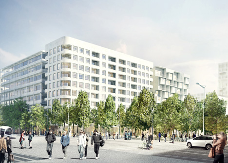
This is a dense but permeable district comprised of a variety of housing, offices and shops, replacing the former marché de gros.
A network of streets and courtyards has been laid down on the basis of the clear, linear, repetitive structure of the old market. Some of the existing covered market structures have been retained, contributing their deeply industrial character to the identity of the new city district while at the same time providing space at moderate prices available in the short term for very specific developments.
The new buildings present a variety of scales and character – low-rise housing closely linked to the ground level and the remaining halls of the covered market, medium-rise construction containing housing units or offices and some residential buildings, higher in certain cases, offering panoramic views while at the same time freeing open space at ground level.
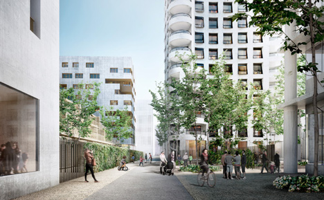
The identity of the quartier du Marché stems from two quite different free spaces: the relatively narrow streets occasionally widening out, and courtyard gardens forming a continuous, tranquil, semi-public space for pedestrians and environmentally friendly transport modes.
The place Centrale, an almost conventional square with its tall trees, is a grand extension to the place Nautique and provides a venue for public events in front of the Hôtel de Région and the new public service building in the east.
The champ
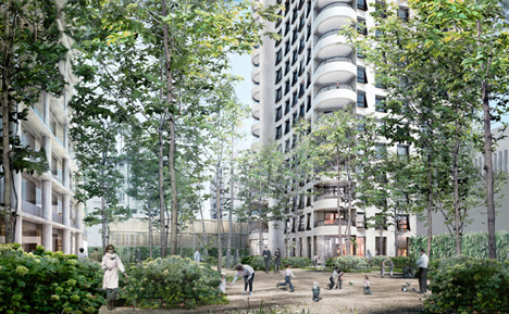
The southern tip of the Confluence is the green counterpart to the densely built-up quartier du Marché. It offers a type of natural environment that is a genuine novelty in Lyon, and we have named it the champ. Activities in the cultural domain, innovative services, higher education and research are suggested as possible occupants for the champ.
We propose that some of the existing warehouses should be retained, since these would facilitate the implementation of developments of this kind, plus the option of defining a series of plots for new buildings in the vicinity.
The division of the overall area is underscored by tongues of vegetation reminiscent of the marshland conditions previously prevailing in the Confluence. Densely planted trees and a selection of plant species provide ground coverage and create the feeling of a public park on what is largely private land. An expansive network of paths for "environmentally friendly" travel runs alongside the planted areas bordering the individual plots.
The first high-rise buildings for mixed use in Lyon will also be located in the champ – twin, finely proportioned high-rise blocks define the termination of the city's main artery. From a more distant perspective, they underscore the "natural event" of the Confluence, that is the convergence of two great rivers which were, originally, the city's very "raison d'être".
The transversale and the Rhône riverfront
A boulevard and two bridges form what we have termed the transversale, the last crossing point over the two rivers and the peninsula, so typical of Lyon. The new transversale, laid diagonally across a squared-off urban fabric, thus faces the Greater Rhône south of the Confluence.
Ultimately, it is planned to reclassify the A7 motorway and to convert it into a city boulevard connecting the Confluence directly to the city's historic centre. A new jetty on the quai du Rhône will enhance access to the river for a whole range of leisure activities. The pont des Girondins will be the main artery connecting up Gerland and neighbouring districts on the Rhône's left bank. In the future, the reduction of the area occupied by the railways will free up still more land for the creation of a continuous green space between the Rhône and the Saône on the Confluence.