Conflict Ecology uses synthetic aperture radar to analyse building damage in Lebanon
Geospatial research studio Conflict Ecology has used synthetic aperture radar to identify damage to over 2,000 buildings in Lebanon in the first five weeks of the recent war between Israel and militant group Hezbollah.
Using synthetic aperture radar (SAR) data from the European Space Agency's Sentinel-1 satellite constellation, Conflict Ecology created an interactive map detailing the areas of destruction in Lebanon.
It found that 2,154 buildings have been damaged between 28 February and 4 April, out of a total 2,489,231 buildings monitored by Conflict Ecology in Lebanon.
The BBC reported on 16 April that over 1,400 buildings in Lebanon have been destroyed since 2 March, based on analysis of verified visual evidence from the ground and satellite imagery, but it said that "the true scale is likely to be much higher". Airstrikes in the country have continued in the weeks since.
According to Conflict Ecology, using radar allows for a more precise analysis of building damage compared to photographic satellite imagery.
Radar identifies damage "that can't be seen in photograph-like satellite imagery"
"Radar is sensitive to damage in the built environment that can't be seen in the kind of photograph-like satellite imagery more commonly used by journalists to visualise building damage," Conflict Ecology founder Jamon Van Den Hoek told Dezeen.
"There are many reasons for this additional sensitivity, but a major one is that we can precisely track how a radar wave is distorted when it reflects off a structure day after day and associate that with potential damage."
"We know how the wave should behave under 'stable' (pre-war) conditions, and so we look for strong deviations from that typical behaviour suggestive of structural damage," he continued. "Optical satellite imagery, by contrast, is at the whim of atmospheric conditions, lighting conditions, and even how bright the sun is, which changes with the seasons."
"Having that extra control allows us to isolate what matters in the satellite signals."
On 28 February, the USA and Israel launched airstrikes on Iran, killing Iranian supreme leader Ali Khamenei. Lebanese militant group Hezbollah, which is backed by Iran, launched retaliatory strikes on Israel, and Israel responded with strikes on Lebanon.
The recent waves of strikes in Lebanon are a continuation of fighting in the country, which has been the subject of airstrikes and an aerial bombing campaign by Israel since the Gaza war reignited conflict with the militant group Hezbollah in October 2023.
"With our war damage mapping work, we try to provide a shared and accepted understanding of the degree and character of war damage to aid decisions on short-term response and longer-term recovery and so that different sides can at least agree on what happened, even if they may disagree on why it happened or what should happen next," said Van Den Hoek.
At least 46 towns in southern Lebanon "heavily damaged or entirely flattened"
Much of Israel's bombing in Lebanon has been concentrated in its southern region.
Research by investigative platform Bellingcat found that, in the region of southern Lebanon occupied by the Israel Defence Forces (IDF) since a ceasefire was agreed on 17 April, at least 46 of 54 towns and villages "have been heavily damaged or, in some cases, entirely flattened".
Using information from community-driven map database OpenStreetMap and satellite imagery from PlanetScope, Bellingcat created an annotated map showing the scale of the damage in southern Lebanon.
Areas of the map were colour-coded to differentiate towns with no significant damage, towns that sustained damage before 2 March 2026 and those that were damaged after 2 March. Users can toggle between satellite imagery taken on 2 March and 8 March to see the level of destruction caused in this period.
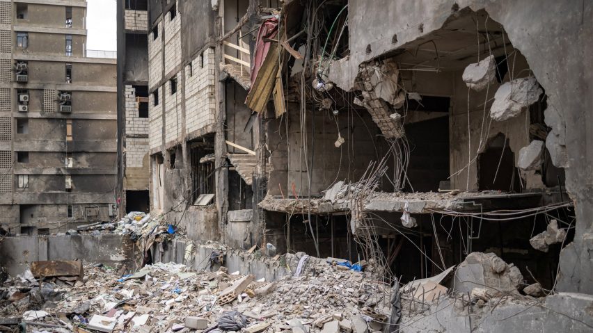
Top photo of damage in Beirut by Ripa8258 via Shutterstock.