
Plant trees in cities to curb deadly heatwaves says Arup's Dima Zogheib
Cities should plant more trees to help prevent tens of thousands of annual deaths from extreme heat, Arup specialist Dima Zogheib tells Dezeen as part of our Designing for Disaster series.
Worsening heatwaves are emerging as the number-one climate-related killer, with an estimated 62,862 deaths associated with extreme heat across Europe in 2022, according to a study published in Nature Medicine.
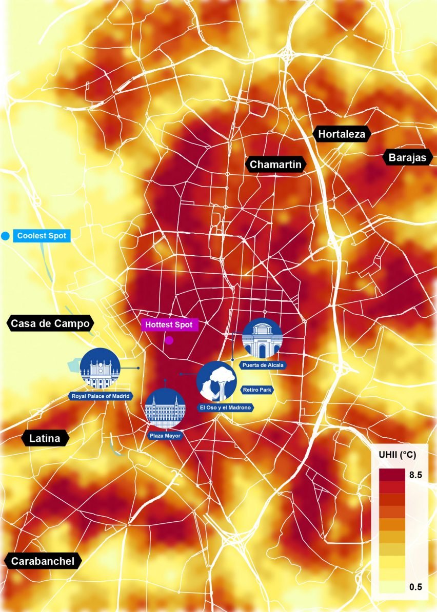
Building consultancy Arup produced the Urban Heat Snapshot in August this year, demonstrating how city temperatures can vary dramatically between neighbourhoods and identifying where hotspots arise in the built environment.
Based on analysis of heat data in six major cities, it found that areas with large amounts of green space had significantly lower temperatures than those without – and therefore that increasing urban planting is one of the key ways to reduce heat-related deaths.
"Some of the very impactful actions are very simple such as tree planting, which has been demonstrated to reduce air temperature significantly and also reduce heat-induced mortality," said Arup nature positive design lead Zogheib, who helped lead on the research.

According to the European Commission, increasing tree coverage in European cities by 30 per cent could have prevented an estimated 2,644 heat-related deaths in 2022.
Zogheib explained that various open spaces in the built environment can be utilised to increase planting and cooling strategies, including roads and rooftops.
"More than 50 per cent of cities is actually open space if you include all the roads, streets and roofs, so these spaces have to play a role, whether it's in cooling cities, inviting biodiversity, or in supporting other resilience challenges," she told Dezeen.
"There are other actions that cities can take, like creating more permeable paving to cool spaces, provision of water fountains and drinking water fountains to keep people cool, and retrofitting buildings by putting in green roofs."
One of the ways to cool the built environment advocated by Arup is retrofitting roofs in London to curb the Urban Heat Island effect, the phenomenon where urbanised areas experience significantly higher temperatures than their rural surroundings.
Working with the Greater London Authority (GLA), the firm published a proposal in June to add reflective and photovoltaic roofs to existing buildings to reduce energy use and lower temperatures in and around buildings, ultimately aiming to improve the health and wellbeing of Londoners.
Research for the GLA proposal and the Urban Heat Snapshot was sourced from Arup's UHeat digital tool, which uses satellite imagery and open-source climate data to map air temperatures.
Air temperature was measured rather than surface temperature because it is closer to the temperature we feel, according to Zogheib.
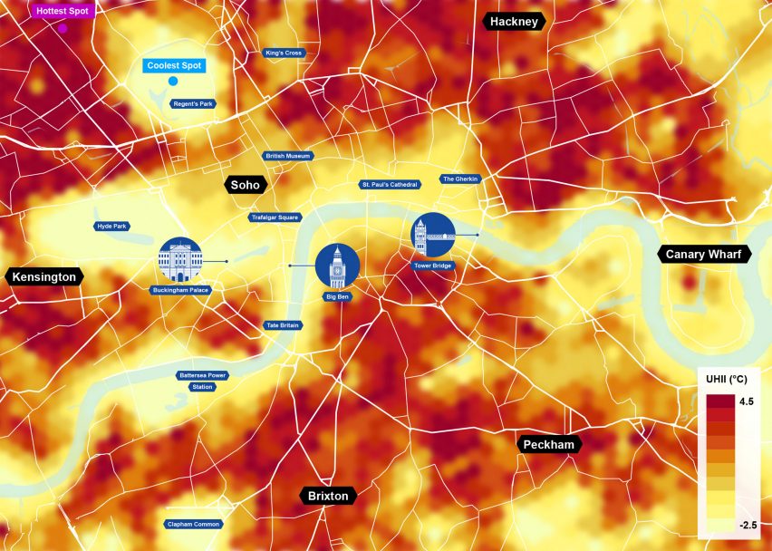
The snapshot found that in the six city case studies, Cairo, London, Los Angeles, Madrid, Mumbai and New York City, temperatures can vary by up to eight degrees Celsius from neighbourhood to neighbourhood.
For each city, a 150 square-kilometre focus area was selected and data was collected for the hottest day in each city in 2022. The focus area was divided into 60,000 square-metre hexagonal blocks to map the differences in air temperatures for both day and night.
As well as temperatures, the UHeat tool modelled building heights, surface reflection, impervious surfaces, and green and blue infrastructure to build a picture of the impact of the built environment on urban heat.
By mapping where hotspots are in cities, Arup aimed to reveal where people can go for cool retreats and also areas where cooling interventions would be most beneficial.
Zogheib argued that as city temperatures rise, it will become increasingly important for everyone to have access to cool refuge.
"The aim of the tool was to raise awareness about the challenge of urban heat," she said. "It's also a call to action to designers, planners, local authorities and municipalities to really take action."
"Yes, this is a design issue, but also this is an equity issue," she stressed. "People who are the most vulnerable are hit by urban heat the most."
Urban heat is becoming an increasing problem as a result of climate change. The number of cities reaching temperatures of 35 degrees Celsius and above is expected to almost triple by 2050.
"We need to curb climate change – all of the climate impacts we are experiencing is because we haven't reduced emissions as much as we should have," said Zogheib. "We need to help cities adapt and we need to help people adapt to this changing climate."
She highlighted that increasing green space in cities is known to have other benefits as well as reducing air temperatures, such as increasing biodiversity and improving the wellbeing of residents.
"I think the opportunity is not just to use heat as an entry point, but to address multiple challenges and deliver co-benefits," said Zogheib.
"For example, if you introduce nature to cities in the form of trees, green roofs and permeable surfaces, this is an opportunity to cool temperatures but also have cities and buildings giving back to the urban environment."
Arup biodiversity and nature specialist Neil Harwood, who also contributed to the Urban Heat Snapshot, argued that built-environment organisations have a leadership role to play in tackling urban heat.
"We can collectively be a real driving force for positive action in this space, not only in our own projects but in influencing the customer base on how they think about some of these issues and deal with it in their day-to-day lives," he told Dezeen.
By looking at a range of cities with different climates in the snapshot, the Arup specialists hoped it would reveal different ways the built environment can adapt to concentrated areas of heat.
"The six cities are very different geographically, climatically and also very different in terms of urban form," said Zogheib. "We wanted to get a diversity of results."
As well as mapping the number of hotspots in cities, the tool can also be used to record changing temperatures after a cooling initiative has been implemented, such as how heat around a street changes after it is lined with trees.
"The failures that have occurred in recent decades in our attempts to deal with these crises have shown us that we need as many tools in our arsenal as possible in order to convince and persuade decision-makers of the benefits of action and change," said Harwood.
"We're seeing a real shift at the moment in terms of evidence-based decision-making. We're hopeful that these tools can be part of the broader suite of efforts to really underpin our decision-making with the right sets of information," he added.
The images are courtesy of Arup unless otherwise stated.

Designing for Disaster
This article is part of Dezeen's Designing for Disaster series, which explores the ways that design can help prevent, mitigate and recover from natural hazards as climate change makes extreme weather events increasingly common.